 geo.be Metadata Catalog
Economy and finance
Type of resources
Available actions
Topics
INSPIRE themes
federalThemes
Keywords
Contact for the resource
Provided by
Years
Formats
Representation types
Update frequencies
status
Scale
-
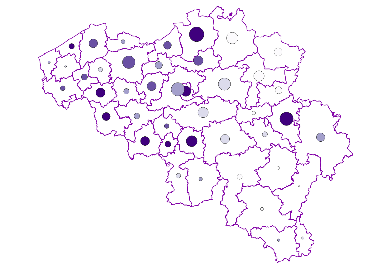
Characteristics of the cadastral parcels - Condition of the building corresponds to the dataset describing the physical characteristics of the built-on parcels such as recorded by the FPS Finance for tax purposes. This dataset is composed of seven classes. The first class shows, at the national level, for each type of built-on land the total number of parcels as well as the number of parcels meeting various qualitative criteria (such as the number of parcels equipped with central heating, or the number of parcels built before 1900). The second class includes this information at the level of the three regions. The following classes do the same at the level of provinces, arrondissements, municipalities, cadastral divisions and statistical sectors. The dataset can be freely downloaded as a zipped CSV.
-

Distribution of real estate assets - real estate companies corresponds to the dataset relating to the distribution of real estate assets owned by legal entities such as recorded by the FPS Finance for tax purposes. This dataset is composed of eight classes. The first class mentions, at national level, for each cadastral income bracket, the number of legal entities with real estate activity (that is to say, registered under the code L of NACE nomenclature) and with real estate capital valued in the relevant bracket as well as the total and median cadastral income of the parcels held by these entities. The assessment of the cadastral income takes into account the shares actually held. The second class includes this information at the level of the three regions. The following classes do the same at the level of provinces, districts, municipalities, land register divisions and statistical sectors. The last class includes this information at the level of the countries for the legal entities which are not settled in Belgium but wich are nevertheless reigstred at the Carrefour Banque of the Entreprises.The dataset can be freely downloaded as a zipped CSV.
-
Distribution of real estate assets - Natural persons corresponds to the dataset relating to the distribution of real estate assets owned by natural persons such as recorded by the FPS Finance for tax purposes. This dataset is composed of eight classes. The first class mentions, at national level, for each age-gender combination, by cadastral income bracket, the number of natural persons with real estate capital valued in the relevant bracket as well as the total and median cadastral income of the parcels held by these persons. The assessment of the cadastral income takes into account the shares actually held. The second class includes this information at the level of the three regions. The following classes do the same at the level of provinces, districts, municipalities, land register divisions and statistical sectors. The last class includes this information at the level of the countries for the natural persons which are not settled in Belgium but wich are nevertheless reigstred in the National Reistry.The dataset can be freely downloaded as a zipped CSV.
-
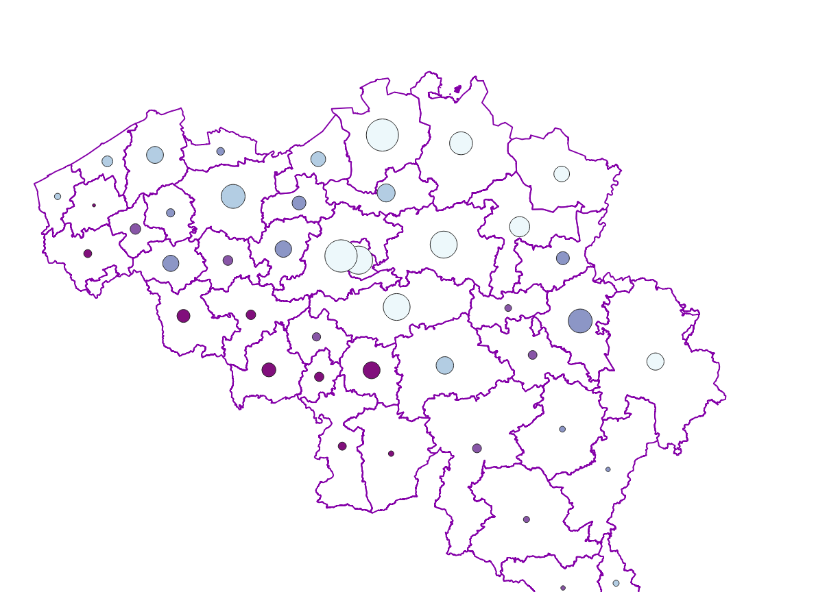
Characteristics of cadastral parcels - Concentration of cadastral income corresponds to the dataset measuring the concentration of cadastral income for parcels of a housing-like nature. This dataset is composed of seven classes. The first class shows, at the national level, for each category of parcels dedicated to housing, the number of parcels and the total cadastral income of the parcels by cadastral income bracket. The second class includes this information at the level of the three regions. The following classes do the same at the level of provinces, arrondissements, municipalities, cadastral divisions and statistical sectors. The dataset can be freely downloaded as a zipped CSV.
-

Real estate leases corresponds to the dataset describing leases on real estate items as recorded for registration purposes by the FPS Finance. This dataset is composed of seven classes. The first class shows, at the national level, for each type of lease within the meaning of the Code of Registration Duties, the number of leases taking effects during the term, the nature of the parties concerned by the contract and the median rent and expenses and the percentiles 25 and 75 of the rent and expenses of the properties concerned. The second class includes this information at the level of the three regions. The following classes do the same at the level of provinces, arrondissements, municipalities, cadastral divisions and statistical sectors. The dataset can be freely downloaded as a zipped CSV.
-

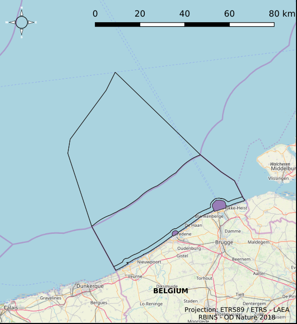
The dataset shows in the form of polygons the sand and gravel extraction sites in the Belgian marine areas as defined by the successive marine spatial plans. A 2014 version illustrates the 2014-2020 plan while the 2020 version illustrates the 2020-2026 plan.
-

Characteristics of the cadastral parcels - Exemption from withholding tax on immovable property corresponds to the dataset describing the parcels exempted from withholding tax on immovable property. The first class shows, at the national level, the number of parcels per exemption category, the total amount of cadastral income of these parcels, their surface area as well as the median cadastral income of each category. The second class includes this information at the level of the three regions. The following classes do the same at the level of provinces, arrondissements, municipalities, cadastral divisions and statistical sectors. The dataset can be freely downloaded as a zipped CSV.
-
The Royal Decree of 22 May 2019 establishing a marine spatial plan defines 5 commercial and industrial zones: Zone A for commercial and industrial activities (Art. 23§1), Zone B for commercial and industrial activities (Art. 23§1), Zone C for commercial and industrial activities (Art. 23§1), Zone D for commercial and industrial activities (Art. 23§1), Zone E for commercial and industrial activities (Art. 23§1). Please refer to the Belgian official gazette (\"Moniteur belge/Belgisch Staatsblad\") for official reference information.
-

The Royal Decree of 22 May 2019 establishing a marine spatial plan defines 12 sand and gravel extraction zones: Sand and gravel exploitation sector 1a (Thorntonbank) (Art. 15§1), Sand and gravel exploitation sector 2br (Buiten Ratel) (Art. 15§1), Sand and gravel exploitation sector 2kb (Kwintebank) (Art. 15§1), Sand and gravel exploitation sector 2od (Oostdyck) (Art. 15§1), Sand and gravel exploitation sector 3a (Sierra Ventana) (Art. 15§1), Sand and gravel exploitation sector 3b (Sierra Ventana) (Art. 15§1), Sand and gravel exploitation sector 4a (Noordhinder) (Art. 15§1), Sand and gravel exploitation sector 4b (Oosthinder-noord) (Art. 15§1), Sand and gravel exploitation sector 4c (Oosthinder-zuid) (Art. 15§1), Sand and gravel exploitation sector 4d (Westhinder) (Art. 15§1), Sand and gravel exploitation sector 5 (Blighbank) (Art. 15§1), Zone for research of the potential of the exploration and exploitation of sand and gravel (Art. 15§4). It replaces the 2014 Marine Spatial Plan, which is included for completeness.. The Royal Decree of 20 March 2014 establishing a marine spatial plan defines in its Art. 11., eleven Management zones with regards to sand and gravel extraction: ten sand and gravel exploitation zones (Thorntonbank, Art. 11 § 1 Sector 1a, Kwintebank, Art. 11 § 1 Sector 2kb, Buiten Ratel, Art. 11 § 1 Sector 2br, Oostdyck, Art. 11 § 1 Sector 2od, Sierra Ventana, Art. 11 § 1 Sector 3a, Sierra Ventana, Art. 11 § 1 Sector 3b, Noord Hinder, Art. 11 § 1 Sector 4a, Oosthinder-noord, Art. 11 § 1 Sector 4b, Oosthinder-zuid, Art. 11 § 1 Sector 4c, Westhinder, Art. 11 § 1 Sector 4d) and one reference zone for monitoring impact of windmills and sand exploitation (Art. 11 § 3). These zones are made available digitally in the resource described by this metadata document. Please refer to the Belgian official gazette (\"Moniteur belge/Belgisch Staatsblad\") for official reference information.
-
The Royal Decree of 22 May 2019 establishing a marine spatial plan defines 2 potential seaport expansion zones: Potential harbour extension Oostende (Art. 12§2), Potential harbour extension Zeebrugge (Art. 12§3). It replaces the 2014 Marine Spatial Plan, which is included for completeness. The Royal Decree of 20 March 2014 establishing a marine spatial plan defines in its Art. 9. § 10, two zones (Art. 9 §10 zone 1, Ostend, Art. 9 §10 zone 2, Zeebrugge) for the potential extension of the sea ports of Ostend en Zeebrugge. These zones are made available digitally in the resource described by this metadata document. Please refer to the Belgian official gazette (\"Moniteur belge/Belgisch Staatsblad\") for official reference information.